Guides · Verified views
What is a verified view?
A verified view – also called an AVR, or Accurate Visual Representation – is a photomontage that shows a proposed building exactly where and how it would appear in a real photograph, at the correct size and position, proven by survey. It’s the image planners trust because its accuracy can be checked.
The short answer
A picture you can prove.
An ordinary CGI shows what a scheme might look like. A verified view goes further: it demonstrates that the building is shown at the right height, in the right place, from a known viewpoint, using survey data and located photography. Because every element can be traced back to measured evidence, it stands up to scrutiny – from planning officers, from objectors, and at public inquiry.
That difference matters. In a contested application, an image that simply looks convincing isn’t enough. The question a committee or an inspector asks is: can we trust that this is honest? A verified view is built specifically to answer yes.
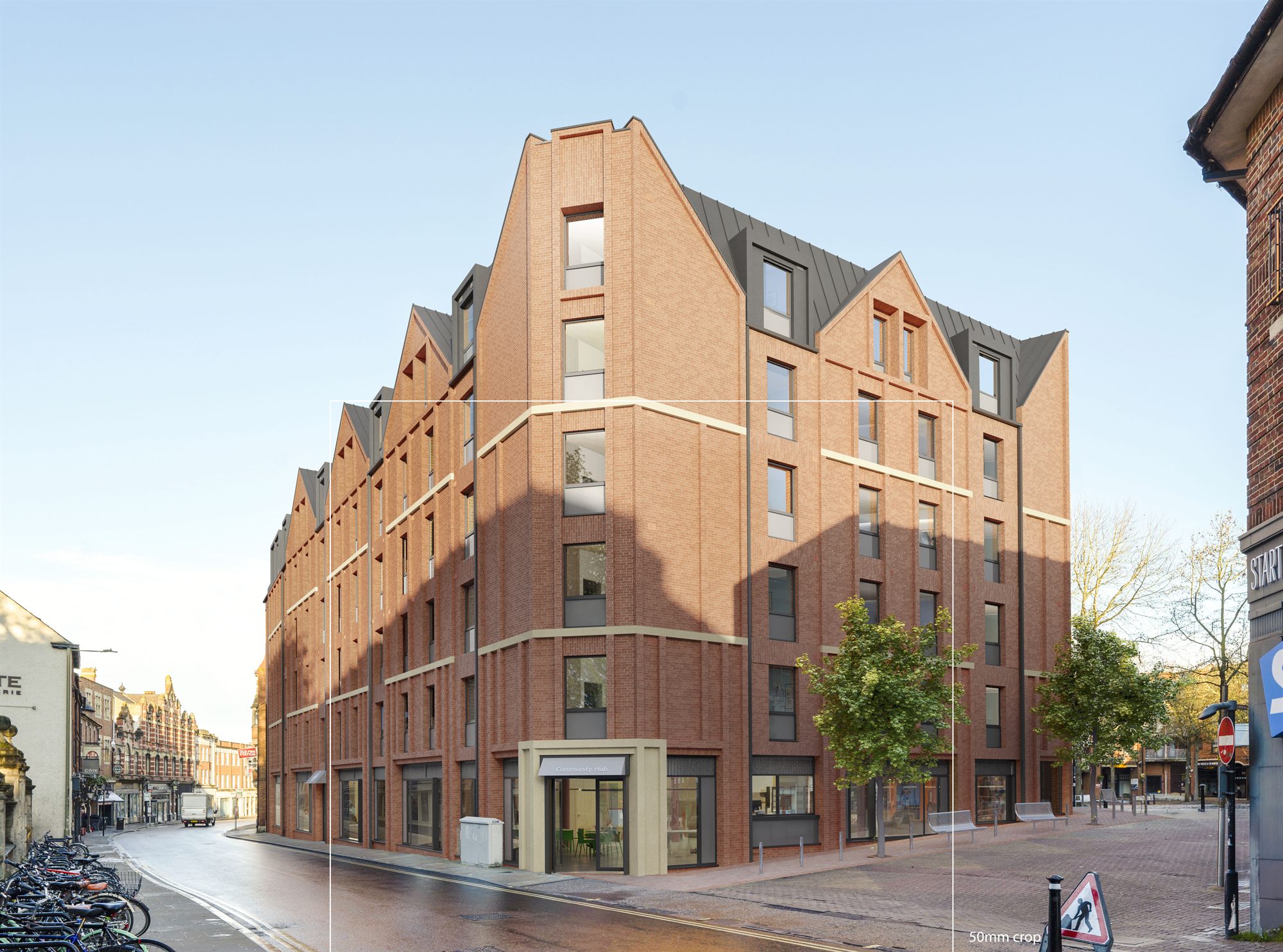
A finished verified view
This is the AVR3 result.
A fully rendered proposal, composited into a real photograph taken from a surveyed, located viewpoint. Because the geometry is locked to the survey, the building sits at exactly the right scale and position within the original shot – the level used for LVIA submission and public inquiry.
How it’s made
Four steps from viewpoint to verified image.
01
Agree the viewpoints
Viewpoints are usually chosen with the planning authority or landscape consultant – the places from which the scheme’s impact most needs to be understood. Each one is recorded so it can be found and re-shot precisely.
02
Survey and photograph
Photography is taken from each located viewpoint with the camera position, height and lens recorded, alongside survey control on site. This is what lets the model be placed with confidence rather than by eye.
03
Build to the survey
The proposed building is modelled in 3D to the architect’s information and aligned to the survey coordinates. A virtual camera is set up to match the real one exactly – same position, same height, same focal length.
04
Render and composite
The proposal is rendered and composited into the photograph, matched for lighting and season. Because the geometry is locked to the survey, the result shows the scheme at its true scale and position – not an artist’s impression of it.
The whole chain, in-house.
Survey, located photography, 3D modelling, rendering and the documentation that backs every view – Blink handles the lot, end to end. That’s what keeps a verified view consistent and defensible from the first photograph to the final image. See how we approach planning work →
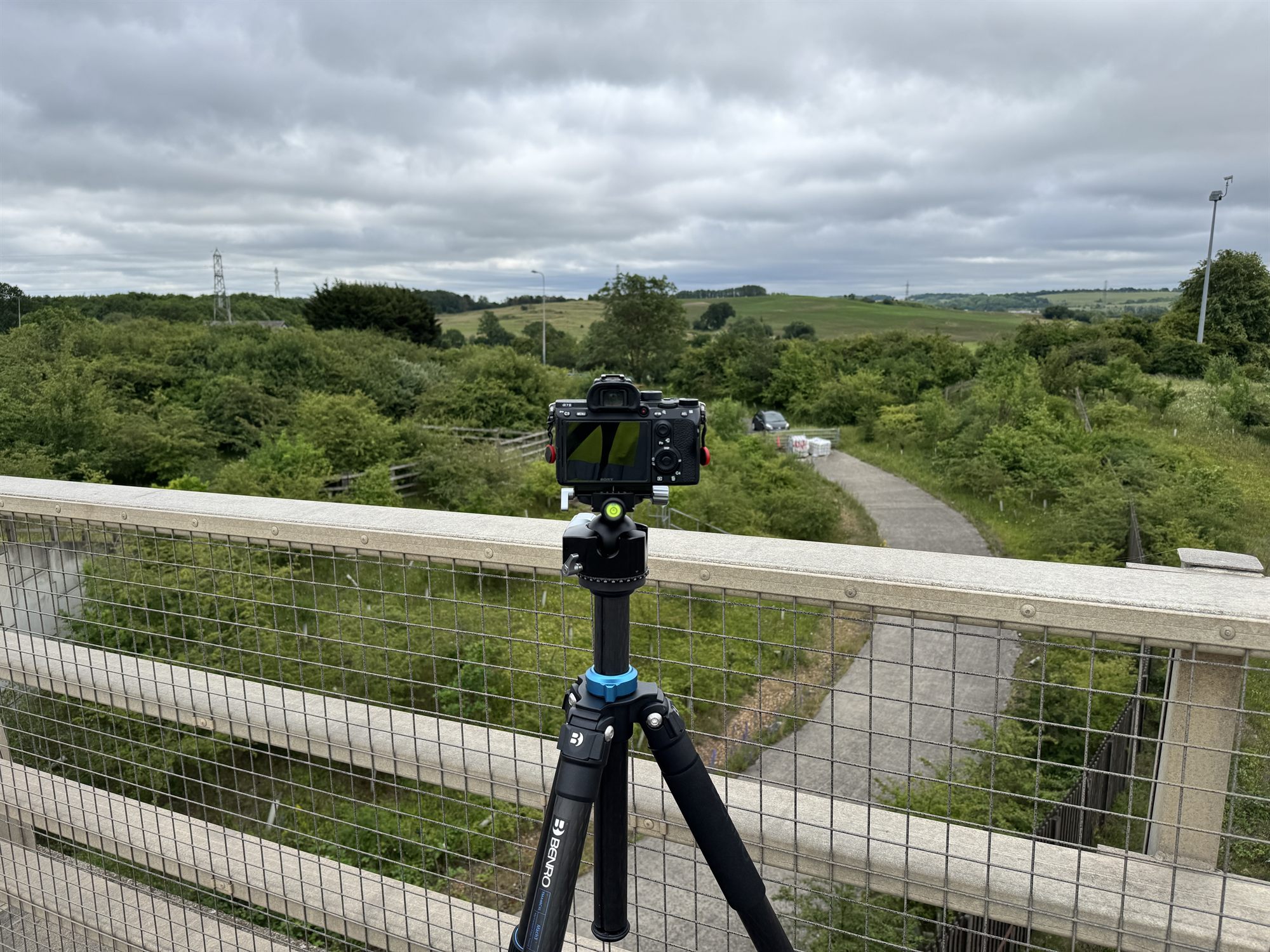
On site
It starts with a located photograph.
Every verified view begins here: a calibrated camera on a levelled tripod, capturing the agreed viewpoint with its position, height and lens all recorded. That measured baseline is what makes the finished image verifiable rather than just convincing.
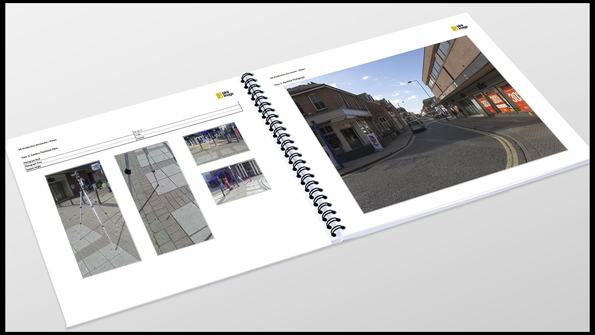
Documented
Every viewpoint, on the record.
For each view we produce a document recording the camera data and the baseline photograph. If the methodology is ever questioned – at committee or public inquiry – the evidence is all there, view by view.
How accurate is “verified”?
AVR0 to AVR3 – the four levels.
A verified view isn’t a single fixed thing. It comes in four defined levels, set out in the Landscape Institute’s guidance as AVR0 to AVR3, each one adding fidelity to the last. The right level depends on the viewpoint and what the application needs – an early massing study and a public inquiry image are not the same job.
AVR 0
Location & size
A simple block outline overlaid on the site photograph, showing the proposal’s position and overall size. The baseline for early assessment.
AVR 1
Accurate wireline
An accurate wireline model of the proposal on the photograph, pinning down its exact form and the degree to which it would be seen.
AVR 2
Shaded model
A solid, shaded representation of the building – form, openings and rooflines resolved – but without final materials, textures or colour.
AVR 3
Full photorealism
A fully rendered, photorealistic photomontage with accurate materials, textures, colours, reflections and lighting. Suitable for LVIA submission and public inquiry.
Match the level to the task
You rarely need AVR3 for every viewpoint. The sensible approach is to agree the right level for each view with the planning authority and your landscape consultant – we advise on this before any work begins, so you’re not paying for more fidelity than the application requires.
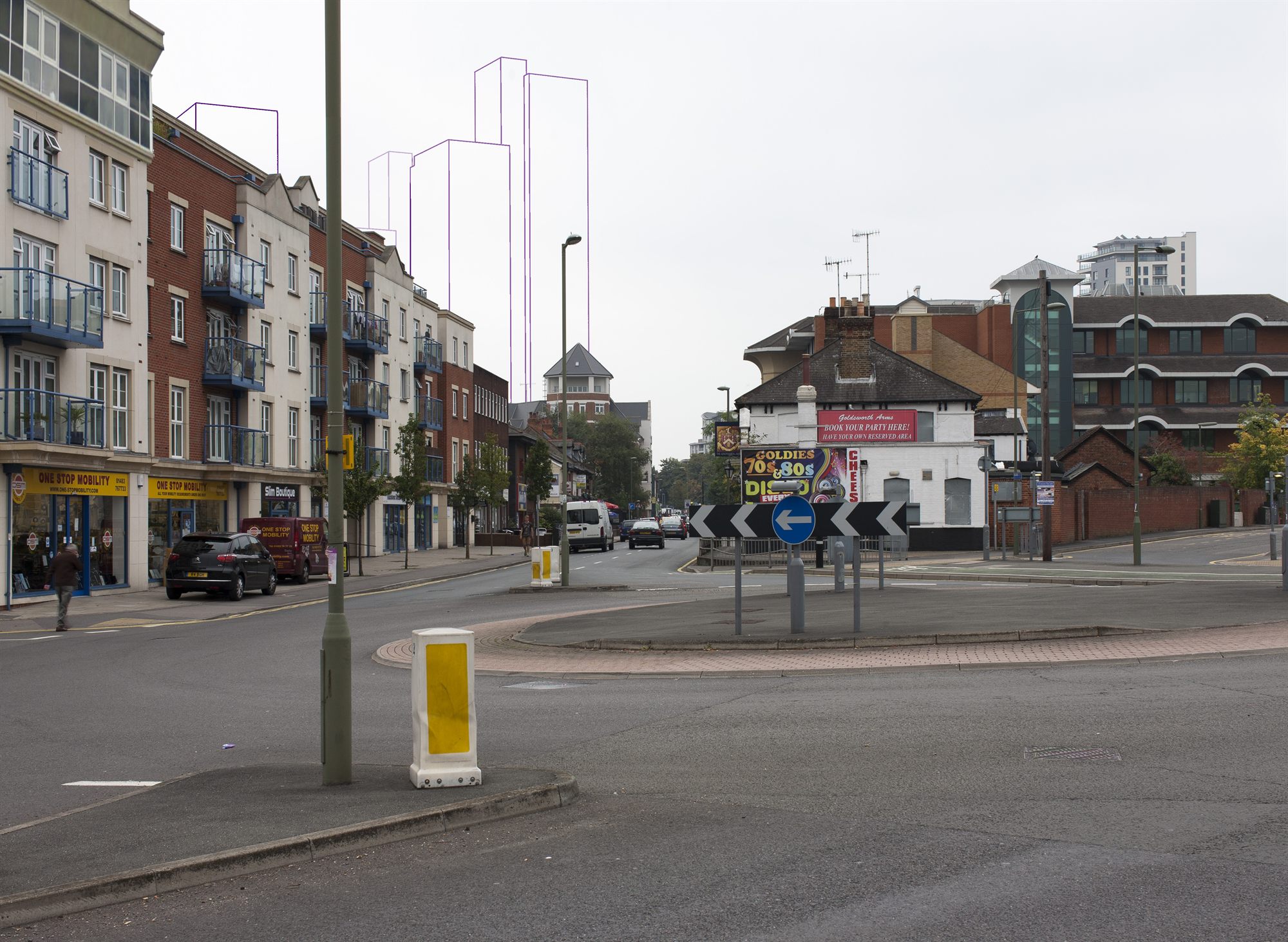
AVR1 in practice
An accurate wireline.
Here the proposal is shown as a precise wireframe on the real photograph, pinning down its exact height, form and how much of it would actually be seen from this viewpoint. Often that’s all a decision-maker needs to judge visibility – no render required.
When you need one
The cases where a verified view earns its keep.
Prominent or tall buildings
Where height and visibility are the whole argument, the image has to prove exactly how much the scheme is seen, and from where.
Sensitive landscapes
Green Belt, conservation areas, protected views and edge-of-settlement sites, where impact on the setting is closely examined.
Contested applications
When objections are likely, a verified view removes the argument about whether the imagery is fair – the accuracy is demonstrable.
Appeal and public inquiry
At inquiry the methodology itself is scrutinised. A properly documented verified view is built to withstand exactly that.
The essentials
- A verified view is a photomontage you can prove – correct scale and position, backed by survey.
- AVR means Accurate Visual Representation – the same thing, and the term you’ll see in planning documents.
- It’s built from located photography and survey data, with the virtual camera matched to the real one.
- There are four defined levels, AVR0 to AVR3 – from a simple outline to full photorealism. Agree the right one for each viewpoint.
- You need one for prominent, sensitive or contested schemes, and for appeal or public inquiry.
Common questions
Verified views, answered.
What’s the difference between a verified view and a normal CGI?
A normal CGI is designed to look good and communicate an idea. A verified view is designed to be accurate and to prove it – the building is placed using survey data and located photography, so its scale and position can be independently checked. In planning, that difference is the whole point.
Is a verified view the same as an AVR?
Yes. AVR stands for Accurate Visual Representation, and it’s the term most commonly used in planning documents. “Verified view” and “verified photomontage” describe the same thing.
Who decides the viewpoints?
Usually the local planning authority or your landscape consultant, sometimes through a scoping exercise. The aim is to choose the views that best show the scheme’s impact – including the difficult ones. We can produce imagery from whatever viewpoints are agreed.
Do I always need the highest AVR level?
No – and over-specifying costs money you don’t need to spend. Many viewpoints are well served by a lower AVR level; the fully photorealistic AVR3 is for the most sensitive views and for public inquiry. It’s normal to use different levels for different viewpoints in the same application. The sensible move is to agree the levels early with the authority, and we’ll advise honestly on what your case actually needs.
Keep reading
Related.
Our planning work
How we produce verified views and CGI that stand up at committee and public inquiry.
Planning & AVR →What does CGI cost?
Why verified views cost more than illustrative CGI, and what moves the price.
CGI costs explained →Industrial & logistics
Verified views matter most on large, prominent sites – the kind logistics schemes often occupy.
The sector →Work with us
Need a verified view for a planning application?
Tell us about the site and where it sits in the process. We’ll advise on the level of accuracy you need and produce imagery that holds up.